|
|
|
Kinyon Digital Library |
Civil War Rosters |
| Home || What's New? || Notes || Census Data || Data By State || Military Records || Links || Tombstones || Poetry || Privacy | |
|
|
|
|
Kinyon Digital Library Copyright © 1999-2013, |
History of the
|
|
Virginia Index || - || Previous Page || Table of Contents || Next Page |
|
|
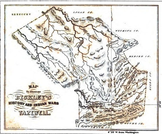
CHAPTER III FORMATION, AND OUTLINE GEOGRAPHY. By an act, passed December 19th, 1799, the county of Tazewell was formed of parts of Wythe and Russell. The following are the boundary lines: "Beginning on the Kanawha line, and running with the line which divides Montgomery and Wythe counties, to where said line crosses the top of the Brushy mountain; thence along the top of the said mountain to its junction with Garden mountain; thence along the top of the said mountain to the Church (perhaps Clinch) mountain; thence along the top of said mountain to the top of Cove creek, a branch of the Maiden-spring fork of Clinch river; thence a straight line to Mann's gap, in Kent's ridge; thence north 45° west, to the line which divides the state of Kentucky from that of Virginia; thence along said line to the Kanawha line, and with said line to the place of beginning." (NOTE: Virginia Statutes, from 1792 to 1806; Vol. II, chap. 27, sec.,1, page 217.)
By an act of the Virginia legislature, passed February 3d, 1835, the line which had hitherto divided Russell and Tazewell counties was altered from Mann's gap, in Kent's ridge, so as to run north 45° 45´ west, to the distance of 974 poles. Which portion was afterward ceded to Tazewell. An act of the General Assembly, passed February 4th, 1828, altered the eastern boundary line, in consequence of the formation of the county of Giles; and, again, in 1837, in consequence of the formation of the county of Mercer; which, however, owing to an omission in the act of Assembly, was not defined till April, 1848. The subjoined Map exhibits the lines as they now stand; which, owing to a want of facilities, is not offered as being in every respect correct, but near enough to convey a good general idea of the shape and geographical features of the county. Tazewell county was named, not in honor of Littleton W. Tazewell, as is generally supposed, but received its name somewhat in the following manner. Simon Cotterel, who was the representative from Russell in 1799, having been authorized to apply for the formation of a new county, drew up a bill, and proposed it on the 18th of December, 1799, but met with the most violent opposition from Mr. Tazewell, a member from Norfolk county, and a relative of L. W. Tazewell then in Congress. Cotterel rose in his seat, and begged the gentleman to withhold his remarks till his bill was matured, to which he assented. Cotterel erased the proposed name and inserted that of Tazewell, and the next day (19th), presented his bill thus amended. Tazewell was silenced; the bill passed, receiving Tazewell's vote. To this stratagem the county is indebted for its name. The county is bounded on the north by the state of Kentucky, Logan and Wyoming counties, Virginia; on the east by Mercer and Giles; on the south by Wythe and Smyth, and on the west by Russell. It has a superficial area of about 1,920,000 square acres, or 3000 square miles, and is traversed by numerous ranges of the Alleghany and Cumberland mountains. Clinch, one of the principal mountains, passes through it in an easterly and westerly direction, about forty miles. This mountain was named, as will be seen in the chapter on mountains, in consequence of the Clinch river. Rich mountain passes through the county about twenty miles; it is a branch of the Clinch. Garden and Brushy mountains are in the southern part of the county, and latter being the county line; they run parallel with Clinch mountain. Paint Lick and Deskin's mountains are also parallel and north of the Rich mountain. They are parts of the same range with East river and Elk-horn, being separated by the Clinch river, in the valley in which stands the town of Jeffersonville. There are no other mountains deserving of notice at this place, except the Great Flat Top, in the north-east corner of the county. The county is traversed by many streams; some of considerable size; the principal of which are Clinch river, Bluestone, La Visee, Dry, and Tug forks of Sandy river and their branches. The Clinch river rises from three springs; the first on the "divides," about ten miles east of the town of Jeffersonville; the second in the valley between Elk-horn and Rich mountains; the third in Thompson's valley, about eight miles south-east of the county seat. The two first unite about one and a half miles east of Jeffersonville, and flow, in a westerly direction, about twenty-five miles, and unite with the Maiden-spring fork, and thence flow through Russell, Scott, Lee, and a part of Tennessee, and, after receiving the Powell river, empty into the Tennessee about sixty miles above Kingston. Bluestone creek rises in the eastern part of the
county; flows in a north easterly direction, and empties into the Great
Kanawha. The different branches (see Map) of the Sandy river,
rising in this county, flow in a northerly direction and empty into the
Ohio. The county is well watered. The climate and soil are
treated of, in other places, under appropriate heads (which see); as
also, the manners, customs, etc. Jeffersonville is the county
seat. |
|
|
Virginia Index || - || Previous Page || Table of Contents || Next Page |
|
Home || What's New? || Notes || Census Data || Data By State || Military Records || Links || Tombstones || Poetry || Privacy |
|||||
|
Site Statistics By
since 17 December 1999. |
|
||||