|
|
|
Kinyon Digital Library |
Civil War Rosters |
| Home || What's New? || Notes || Census Data || Data By State || Military Records || Links || Tombstones || Poetry || Privacy | |
|
|
|
|
Kinyon Digital Library Copyright © 1999-2013, |
History of the
|
|
Virginia Index || - || Previous Page || Table of Contents || Next Page |
|
|
CHAPTER VI DESCRIPTIVE GEOGRAPHY MOUNTAINS The principal mountains of Tazewell are Clinch, Rich, East River, Brushy, Garden, Paint Lick, Deskins, and Flat Top. they have an elevation, above the valleys, of about eighteen hundred feet, and about three thousand above the level of the sea. For remarks upon their geological formation I would refer the reader to the Transactions of the Jeffersonville Historical Society. The general course of these mountains is N. 67ş E. Clinch mountain, which receives its name from Clinch river, extends through the entire length of the county. It has several gaps, through which wagon-roads pass. Rich mountain, so called from the character of its soil, is a branch or spur of Clinch mountain, running parallel to it its entire length. East River mountain, so called from a stream of that name flowing along near its base, begins a few miles east of Jeffersonville, and runs parallel to the Rich mountain to the county line on the east. Brushy mountain, receiving its name from the brushy character of its growth on the south side, runs in the same direction as the Clinch, and forms the southern boundary line of the county. Paint Lick mountain is a continuation of the House and Barn mountain in Russell county, and is separated from it by the Maiden Spring fork, of Clinch river. There was once a great elk and deer lick, near its western end, and there are many paintings (still visible), supposed to have been executed by the Shawanoe Indians, or perhaps, by the Cherokees. The paintings represent birds, women, Indian warriors, etc. From these paintings, the lick was named, which was soon applied to the mountain. It rises near the western county line, and runs in the general direction to near Jeffersonville: it here sinks, to admit the passage of another fork of Clinch river and again rises, forming Elkhorn mountain. Deskins' mountain, so called from an early settler, runs parallel, and near the Paint lick, for about the same distance. The Great Flat Top, rises from a spur of the Cumberland mountains, which traverses the county. It is in the north-east corner of the county, and on it, corner Tazewell, Mercer, and Wyoming counties. It receives its name from a large level area on its summit. To notice the remaining small mountains and great ridges, would occupy too much space. The northern part of the county is much cut up with them, and renders it almost valueless for farming purposes. For grazing, however, it cannot be excelled. VALLEYS. The principal valleys, are the Clinch, Abb's, Poor, Baptist, Thompson's, and Deskins'. They are not so wide as those of the adjoining counties, yet sufficiently broad, to afford room for some beautiful farms. Clinch valley, through which flows the north fork of Clinch river, and from which it was named, is the most important, and, perhaps, contains the best lands in the county. In it is located the seat of justice, and through it passes the Fincastle and Cumberland Gap turnpike. Abb's valley, so called from Absalom Looney, the first white settler, is a narrow, but beautiful and fertile valley under which runs a creek of considerable size, its entire length of about twelve miles---It is much celebrated, in consequence of the horrible massacres which were perpetrated in it. Poor valley, is between Clinch and Brushy mountains: it is narrow, and the lands poorer, than most of the surrounding country; yet, in point of mineral wealth, it is one of the richest valleys in the county. It is several hundred feet lower than the adjoining valleys. Thompson's valley, between Rich and Clinch mountains, is one of the most beautiful in the county. The lands are good and in a high state of cultivation. It is from two to three miles wide, and was so called from a large family residing in it, and who were among its earliest settlers. Baptist valley, was so named from the number of persons belonging to the Baptist denomination of Christians, who settled in it. It is a valley of some importance, the Tazewell C. H. and Kentucky turnpike passing through its entire length. Deskins' valley, between a range of hills, and Deskins' mountain, received its name from an early settler. There are some fine farms in it, though the valley is small. RIVERS AND CREEKS. Clinch is the principal, and Sandy, the most important in the county. The latter heads in the county, and is navigable to the county line, for flat-boats. East river, Tug, and Bluestone creek, are considerable streams. Clinch river heads in this county, and receives its name from an incident which occurred on it in 1767. A hunter named Castle, left Augusta and went to what is now Russell county, to hunt with a party of friendly Indians, who were living on it. This tribe made frequent visits to the settlement, carrying off horses, and such other stock as they could get a hold of. A man named Harman, who was robbed of some things, and believing Castle to be the instigator to these acts, applied to a Mr. Buchanan, a justice of Augusta, for a writ to arrest Castle and bring him to trial. The writ was issued, and a party raised to arrest him, among whom, was a lame man named Clinch. The party went to Castle's camp, and attempted to arrest him, but the Indians joined Castle, and Harman's party were forced to retreat across the river. In the hurry of the moment, Clinch got behind, and while fording the river was shot by an Indian, who rushed forward to secure his scalp, but was shot by one of Harman's party. The vulgar tradition is, that an Indian was pursuing a white man, who clenched, and drowned the Indian in the stream. I had the former statement, however, from a grandson of the magistrate who issued the warrant for Castle's apprehension. As before stated, the river rises in the county, east of Jeffersonville, running in a westerly direction, and receiving numerous small streams, till it reaches what is known as New Garden, in Russell county. It is then joined by the Maiden Spring fork, which rises in Thompson's valley, flows a short distance, sinks several miles, and rises again near what is known as Maiden Spring, owned by Col. Rees T. Bowen, and one of the loveliest places in Tazewell. This spring is named also, from an incident which happened to Rees Bowen, the earliest settler near it, and grandfather of its present owner. When Mr. Bowen first saw the spring, he discovered a fine young female deer, feeding on the moss within the orifice from which gushes the spring. He shot it, and when he went to get his deer, saw a pair of elk horns standing on their points, and leaning against the rocks. Mr. Bowen, was a very large and tall man, yet he had no difficulty in walking upright under the horns. He chose this place for his home, and the spring and river, have since been know as Maiden Spring and Fork The Sandy river has several branches heading in this county, the most important of which, are the La Visee, Dry and Tug Forks. La Visee, has many branches in Tazewell, and is navigable for flat-boats, to the county line. The first white man who ascended it, was a Frenchman, who found a well-executed design, or painting upon a peeled poplar; hence its name---"la," translated, meaning the, and "visee," meaning a design, aim, or representation. It is sometimes called Louisa fork, from Louisa C. H., Kentucky, near its junction with the Tug river. The Dry fork, heads about six miles N. W. from Jeffersonville, and flows into the Tug river. So named, because the waters on it get very low during the summer. The Tug river, is named from an incident which took place in 1756. "Maj. Andrew Lewis was appointed to command this expedition (one ordered by Gov. Dinwiddie, to march against the Shawanoes on the Ohio), and directed to proceed against the Shawnee villages, near the mouth of the Great Kanawha. Maj. Lewis led his men, through great peril and suffering, within a few miles of the Ohio, when a messenger, ordering a return of the expedition, reached him. The whole party suffered intensely during this march, and once were reduced to the necessity of cutting their buffalo-skins into tugs, and eating them; hence the name Tug River." (NOTE: De Hass's History of Western Virginia, pages 202-3) The river is in the northern part of the county, and abounds in fine fish. It is too much obstructed by falls, to be navigable at any stage of water. East river, so called from the direction which it flows, is a small stream, emptying into the Kanawha. Bluestone creek or river, also, flows east, and is remarkable for the clear blue color of its waters; hence its name. In addition to these rivers (which are but large creeks), there are quite a number of creeks, only a few of which will here be noticed. Great Indian creek, rises in what is known, as the Sinking waters, and flows southerly, into Clinch river, sixteen miles west of Jeffersonville. A man named Ray, was killed on it, by some Indians. As its head is a spring, said to possess the property of petrifying nuts, twigs, etc., some of which are in my possession. Cove creek, rises in the Cove, and meanders under ground through it, coming out at Maiden Spring. Numerous openings from the surface enable stock to get water from it. Wolf creek, rises in Burk's Garden, flows into the Kanawha (here called New River), and was named from a rencounter with a wolf on its margin. There are hundreds of others, each one of which, by its name, perpetuates some traditional incident; but I have not space to notice them. DESCRIPTION OF PARTICULAR LOCALITIES. This is a large area of nearly level land, containing about fifteen square miles, and situated at the west end of Thompson's valley, between Clinch and Short mountains, which was evidently, at one time, connected with the Rich mountain. The waters seem to have accumulated, and forced a way through that spot now know as Maiden Spring. The land is very fertile, well timbered and watered, and the surrounding farms in fine order. Add to it the adjoining lands and residences of Maj. H. S. Bowen and Col. Rees T. Bowen, and I know of no place or section in Tazewell county, of the same extent, so desirable. The society is good, and the inhabitants very hospitable. I hesitate not to call this the garden-spot of Tazewell county. It was settled in 1772, by John Craven, who was followed, the next year, by Rees Bowen, David Ward, and William Garrison. The latter, however, settled on its very edge. The descendants of these men are still living in the Cove. The Wards, Bowens, Gillepsies, Barneses, and Youngs, constitute a major part of its population. The scenery from here is fine, and the climate warmer, than other parts of the county.
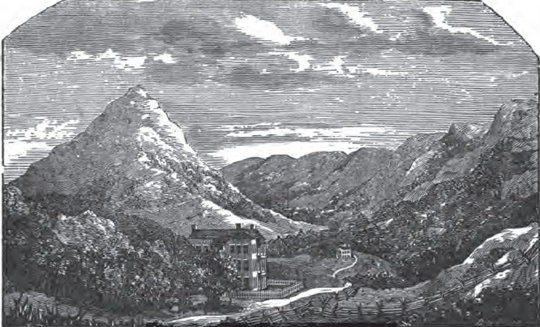
Cove and Maiden Spring Farms. RICHLANDS. This locality is in the western part of the county, on Clinch river, and is noted for its fine lands. It is a pretty place, and in every sense of the word, desirable. BLUESTONE. Here is to be found another fine farming country; the people moral and prosperous, and blessed with "peace and plenty." It is in the eastern part of the county, on Bluestone river. The Fincastle turnpike passes through it. The settlement contains a division of the Sons of Temperance, which speaks much for its population. BURK'S GARDEN. The following description of Burk's garden, was written by Thomas G. Harrison, a gentleman of Jeffersonville, and published in the Jeffersonville Democrat, in September 1850, which, polished in novel style as it is, is in the main correct. "Burk's garden, in Tazewell county, Virginia, considered in its geological and geographical character, abounds with a beauty perhaps unparalleled by any other scope of land, of equal area, on the American continent. It is about ten miles in length, from east to west, and five in breadth, from north to south; entirely surrounded by lofty mountains, save a narrow pass, through which flows Wolf creek, a small, rippling rivulet, which derives its name from the number of wolves caught in traps, and other wise exterminated on its margin. "Seventy years ago, a man named Burk ascended the Garden mountain on the south side, and from its summit beheld, for the first time ever civilized man did, this enchanting vale, rich in the exuberance of nature's virgin dress. According to a well-authenticated tradition, Burk descended the mountain late in the evening, accompanied by his dogs and gun, and erected his camp near a tinkling fountain; breaking, for the first time, the primeval solitude that had reigned in this dell since creation's birth, the undisturbed genius of woods. At every stoke of his ax in the gnarled oak and smooth poplar, echo, aroused from her lair, answered loud, and flew shrinking back into her covered recess, as if mad at the rude invasion. The branching antlered buck, and screaming panther, stalked around his camp with an air of curiosity, as if wondering what his presence could mean, yet proud of their native freedom, and unconscious of their deadly foe. What a beautiful prospect was spread out before Burk on that solitary evening! Flowers of every hue and odor, and bright speckled trout, flirting the crystal waters with their glittering fins, and anon skimming the surface of the pearly rill: birds of gaudy plumage and silvery sound, apparently sporting in an ecstasy of glee at the idea of having for an auditor, a fair visaged biped of stately step and comely form; and perchance they poured from their mellow throats a thousand varied choruses of harping melodies, soothing and charming the wrapped senses of the astounded Burk, until he fancied himself in a very Jehosaphat, or an elysium, in which every fleeting zephyr was freighted with a tuneful intelligence, whispering happiness, or, as Milton would say, "It seemed a fit haunt for the gods," As, in truth, it was a real haunt for the wild gods of Columbia---the red men of the forest. Two Indian tribes, the Cherokees and Shawanoes, frequented south-western Virginia, at the time Burk explored these wilds. He was an excellent hunter and pioneer, of the Daniel Boone style; and buffalo, elk, and deer, were quite numerous, at this period, in Burk's garden (I understand that buffalo were scarce. B.)--- for wild pea-vine, and blue-grass, grew four or five feet high, from mountain to mountain---making it a perfect paradise for the grazing species." * * * * * * * * * "In 1848, the legislature of Virginia granted a charter for the construction of a road, called Fancy gap and Tazewell C. H. turnpike, which will pass through the interior of the garden, and which, when completed, will add greatly to its importance." I have not space for the insertion of the whole article, and hence have been compelled to partially mutilate it. There is some dispute about Burk having discovered the garden; some contending that it was discovered by Morris Griffy, a step-son of Burk. The garden is located in the south-east part of the county, about sixteen miles from Jeffersonville. It was evidently, at one time, nothing more than a pond, which eventually, forced its way through Wolf creek pass. The soil is certainly alluvial. I beg to differ with Mr. H. about its being the most desirable part of the county, for two reasons, first, its climate is too cold to mature corn well, and secondly, it is hard to access. It is 900 feet higher than Jeffersonville, or 1000 feet above the bed of Clinch river. Its winters are four weeks longer than those of the country around the C. H., and six weeks longer than those of the Cove. Small grain and grass do exceedingly well upon its soil. COUNTRY AROUND JEFFERSONVILLE. The lands here are well improved, and will compare favorably with any in the county. There are many fine farms near the town, among which may be mentioned those of Thos. Peery, Esq., Col. John B. George, Kiah Harman, Henry, Elias, G. W., and William Harman, Joseph, and Thomas G. Harrison, A. A. Spotts, Hervey G. Peery Esq., and Dr. H. F. Peery. 50,000 acres of these lands, are worth from forty to fifty dollars an acre, and little could be purchased for even that sum. These farms are well stocked, and laid down in fine grasses, among which may be mentioned, blue-grass, long English, timothy, and clover. The dwellings are good, and an air of ease, and opulence, is everywhere seen. The water is an excellent quality of blue limestone. CLEAR FORK SETTLEMENT. This is in the eastern part of the county, on the creek of that name. It has the reputation of being a fine farming country, and a place every way desirable. When Tazewell county shall be generally as well improved, as the places which have been mentioned, it may well be called a Mountain Garden. JEFFERSONVILLE. Jeffersonville is the seat of justice or capital of the county, and is situated on an elevated plain in Clinch valley, about one mile from the river. It is centrally situated in the county, if regarded from east to west, but not so from north to south, being within ten miles of the southern line, and upward of forty from its northern boundary. The surrounding scenery is indeed beautiful. Immediately south of the town rises Wolf creek knob, or the Peak, the summit of which, in winter, is frequently covered with snow while verdant grass is seen lower down the mountain side in beautiful contrast with the dreariness of the snow-mantled top. In summer it is beautifully decorated with laurel and ivy blossoms; great quantities of these shrubs growing near its summit.
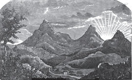
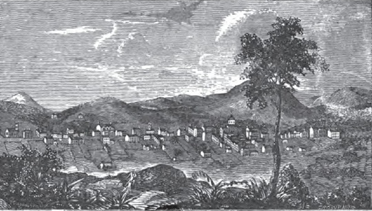
Scenery West from Jeffersonville. To the east are seen the three abrupt and rocky heads of East River mountain; to the west, like ends of Paint Lick and Deskins' mountains, which, however, are somewhat obscured by large hills. To get a good view, a hill north of the town must be ascended; from this hill the view on the opposite page was taken. In this view, the high peak to the left represents Morris's knob. The other two to the right, are the ends of Paint Lick and Deskins' mountains. In the distance are seen mountains in Russell county. North of the town a pleasant succession of hills rise, which give a beautiful aspect to the country, especially when the forests are covered with foliage. The town contains about eighty houses, and numbers over three hundred inhabitants. Few villages anywhere in south-western Virginia, have a neater appearance, or present a more business-like scene. The streets are laid out at right angles, the principal ones running east and west. The main street is well paved and partially McAdamized; it will soon be completed. The houses are usually well built, and painted white. A better site might have been selected for its location, but the land could not be purchased. The most objectionable feature to its present location is the difficulty of getting water. A single spring supplies most of the town with water, which is hauled in barrels. Considering the danger of the town in case of fire, it is a little strange why water has not been brought into the town by pipes from a spring of purest water three or four hundred feet above the town on the side of the mountain. The cost of doing so would not probably exceed $1,000.
Jeffersonville. Jeffersonville was founded in June, 1800, and named from Thomas Jefferson. The name really signifying Jefferson's village. The following is a business directory of the town: Northwestern Branch Bank---Main St.,
E. C. H. Jeffersonville Savings Bank---Main
St., nearly opposite Court House. Union Hotel.---Main St., one door west of the C. H. Proprietors, R. W. & T. Witten. Virginia House.---Main St., three doors east of C. H. Proprietors, McCarty & Bosang. Post Office.---Opposite C. H. P. M., A.A. Spotts. Mail Arrivals. Northern mail, via Wytheville, Tuesdays and Fridays. Mail Departures. Northern mail, via Wytheville, Wednesdays
and Saturdays. Physicians. H. F. Peery.
Office, west end Main St. Lawyers. Joseph Stas. Office, Main Street. Clerk Superior And County Courts. G. W. G. Browne. Office, C. H. Jailer. William J. Crutchfield.. Printing Office S. W. Advocate. Geo. Fred. Holmes, Editor. Merchants. Witten & Chapman, Main Street, Groceries and Dry
Goods. Blacksmiths. Granville Jones, Main
Street. Churches Methodist,
Main Street, Rev. G. W. G. Browne, Pastor. Masonic
Lodge,
Main Street, Tuesdays. LIBERTY HILL. Situated on the Fincastle and Cumberland Gap turnpike, eight miles west of Jeffersonville, is a flourishing little village, and would soon grow to importance if it was so located as to afford building-ground: but situated in a narrow valley, between high hills, there is little room for expansion. It has one hotel, three stores, and several industrial establishments. Notwithstanding its proximity to Jeffersonville, it has considerable trade. It was founded in 182_, and named from a
church used by all denominations of Christians. "Hill" was
added to distinguish it from Liberty in Bedford county, Va. It is
well supplied with water, and is a pleasant place. |
|
|
Virginia Index || - || Previous Page || Table of Contents || Next Page |
|
Home || What's New? || Notes || Census Data || Data By State || Military Records || Links || Tombstones || Poetry || Privacy |
|||||
|
Site Statistics By
since 17 December 1999. |
|
||||